The LiDAR (Light Detection and Ranging) is a remote sensing system that sends laser pulses towards what is in front of us and calculates how long it takes for the reflected light to return to the sensor. From this information it can obtain the distance from objects and, by repeating the measurement in many points, it can build a three-dimensional representation of the environment around us. It is a technology that we inherited from the scientific world, but which today also finds wide applications in the consumer world, being now easy to find on smartphones and robot vacuum cleaners, as well as on systems developed for self-driving cars. Let’s get to know her more closely.
How LiDAR works and the differences with RADAR
The name LiDAR comes from English Light Detection and Rangingthat is, detection and measurement of distance using light. The principle resembles that of RADAR, acronym for Radio Detection and Ranging: the latter, by emitting radio waves and measuring the time that passes before the signal returns after encountering an object, allows us to calculate the distance at which it is located and, in some cases, also its speed and direction of movement. In LiDAR, however, the source is a laser, a very concentrated light beam characterized by a precise wavelength. By measuring the so-called ToF (Time of Flight), i.e. the interval between the emission of the pulse and the return of the light, the sensor can establish how far away what it hit is.
However, the light used by LiDAR has a much shorter wavelength than the radio waves of RADAR. This allows you to obtain more precise measurements and distinguish smaller details, obtaining information not only on the distance, but also on the shape of the objects that are identified.
A single detection can therefore become part of a real three-dimensional scan of the environment. By repeating the pulses, the system can reconstruct the position of surrounding elements and, by observing their changes over time, obtain information on the movement, speed and even orientation of the objects themselves: for example, it can understand how they are rotating and whether they are facing towards the sensor or in the opposite direction.
This ability also depends on how the laser is used. The LiDAR sensors present in devices such as some smartphones do not simply emit a single beam, but project a grid of lasers. This way they can quickly gather many points of information and develop a more precise picture of their surroundings. The result can be used, for example, to create a three-dimensional virtual model of a room, as you can appreciate from the following image.
Use in consumer electronics: what is it for on smartphones, ARs and vacuum cleaners
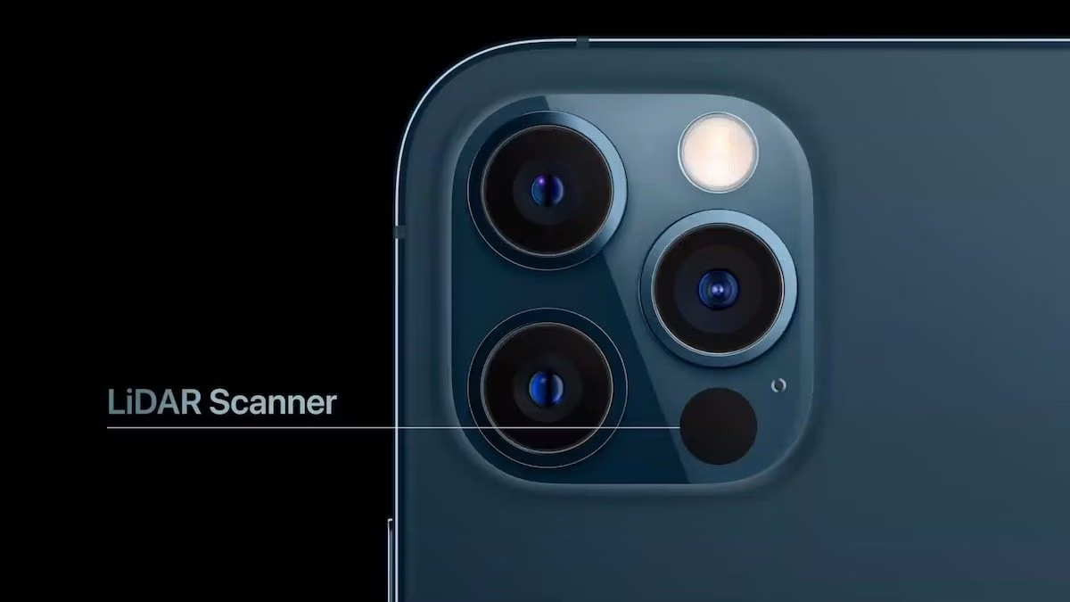
Let’s try to give some concreteness to this technology by reviewing some examples of the use of LiDAR in consumer electronics. Let’s start with the object that we constantly have in our pockets: the smartphone. More and more smartphones on the market have a LiDAR sensor which finds application especially in computational photography, which uses advanced software and algorithms based on artificial intelligence to process images and overcome the physical limits of a camera’s hardware. LiDAR, being able to scan the surrounding environment in three dimensions, allows it to provide the chip that will process the acquired images with valuable information on depth which can help, for example, to obtain more precise shots, especially in low light conditions.
Another particularly interesting field is that of Augmented Reality, or AR: in this case computer-generated images are superimposed on what we see in the real environment through the smartphone screen.
The same ability to “see” space is exploited by robot vacuum cleaners. LiDAR can help them map the rooms of our home, so they can orient themselves in cleaning operations, and also recognize obstacles that will allow the robot to determine the best routes to complete the job.
In self-driving cars, however, LiDAR can help build a detailed map of the vehicle’s surroundings, identifying terrain, roads, cars, people, animals, and so on.
LiDAR before it came to us
Before arriving in consumer electronics, LiDAR was primarily a scientific instrument. It has been used by aircraft and drones to map the Earth’s surface and is now used in areas such as topography, archaeology, geology, seismology, forestry and meteorology. Systems installed on aircraft can produce high-resolution maps and 3D representations of the territory, while specific wavelengths also allow the study of particles, aerosols and molecules present in the atmosphere.
The technology began to develop shortly after the invention of the laser. In 1961, the Hughes Aircraft Company created the first system similar to LiDAR for satellite tracking, combining a laser beam with instruments capable of calculating the distance through the signal return time. In the following years, LiDAR found applications in meteorology and atmospheric research, until it became known to the general public during the Apollo 15 mission in 1971, when a laser altimeter was used to map the surface of the Moon.
Today, also thanks to the reduction in production costs of sensors, that same idea has entered objects we use every day. Remember this the next time you are about to take a portrait photo with your smartphone.