Mineral exploration is undergoing a profound transformation, driven by the adoption of new technologies that aim to reduce the duration and costs of geognostic investigations, while increasing the effectiveness in identifying underground mineralization. In 2025, an innovative approach involving the use of geophysical and satellite measurement systems – integrated and processed through artificial intelligence – developed by the Canadian company Fleet Space Technologies, was used to identify potential lithium deposits underground in Quebec, Canada, as well as to guide drilling activities, minimizing costs and operational risks. Three wells, drilled during the year, intercepted numerous mineralized intervals with a relatively high content of lithium oxide, between 1% and 2%, confirming the effectiveness of the approach adopted.
The James Bay lithium deposit in Quebec
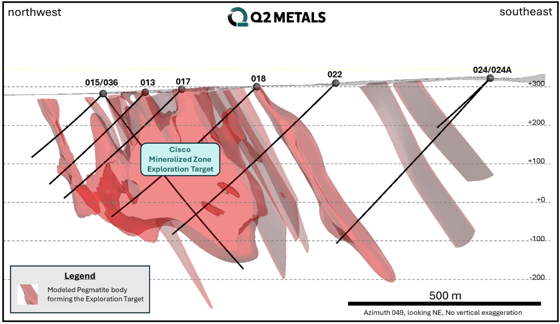
The discovery occurred as part of the “Cisco Lithium Project”, a district-scale exploration project launched in the Eeyou Istchee James Bay region, in Quebec, under the guidance of the Canadian company Q2 Metals Corp. The deposit extends over an area of approximately 410 km2 and comprises between 215 and 329 million tonnes of mineralized rock, with an average lithium oxide content of between 1 and 1.38%: this translates into a total lithium oxide content estimated between 2.1 and 4.5 million tonnes. Lithium is extracted from pegmatitic igneous rocks containing spodumene – a lithium aluminum silicate mineral – located at depths generally less than 500 metres. The project is considered one of the most important in the field of lithium extraction from crystalline rocks, to the point of being considered a future central node of the lithium production chain in North America.
The results of the drilling
The three new wells drilled in 2025, and designated CS25-036, CS25-038, and CS25-039, have penetrated significant mineralized levels. According to the press release issued by Q2 Metals Corp., the CS25-038 drilling would have intercepted seventeen mineralized intervals, including the largest with a thickness of approximately 66.5 meters and a lithium oxide content of 1.55%. The CS25-039 well would have crossed twelve distinct mineralized intervals, while the CS25-036 well would have crossed nine mineralized intervals, including the largest with a thickness of 272.5 meters and a lithium oxide content of 1.61%.

How ExoSphere works: satellites and sensors to study the subsurface
For the identification of mineralizations, the positioning of wells on the surface and their trajectory underground, the ExoSphere multi-geophysical and satellite imaging technology, developed by Fleet Space Technologies, was adopted. In fact, the company has a small constellation of satellites in low Earth orbit that receive and process data from sensors embedded in the ground in the study area. These sensors measure various passive geophysical properties of the subsurface and communicate directly with satellites, transmitting the information in data packets. In particular, ExoSphere technology includes sensors forAmbient Noise Tomography (environmental noise tomography), which monitor and map natural and continuous seismic noise, systems Natural Source-Field Induced Polarizationwhich detect the response of the subsurface to the propagation of natural electric fields, as well as instruments for magnetotelluric and gravimetric measurements. The use of satellite systems for data collection and processing makes it possible to significantly reduce the environmental impact associated with traditional geognostic investigations and, at the same time, to carry out measurements in areas that would otherwise be difficult to access with conventional investigation techniques.
From raw data to 3D model: the role of artificial intelligence
The results of the geophysical investigations, together with data from other measurements – including seismic reflection surveys, existing drillings, geological mapping and historical data – are then “fed” to an artificial intelligence system, which learns from this information and integrates it in order to obtain a single 3D geological and structural model of the subsurface. The model will contain detailed information on the typology, i.e. lithology, and distribution of the rocks, as well as probabilistic estimates on the presence of specific mineralizations, thus allowing the most promising areas for drilling and the ideal trajectory of the wells to be delineated. Overall, this technology allows the exploration and drilling phases to be optimized, reducing uncertainties, errors, times and costs. The benefits of the approach are evident from its application in the Cisco Lithium Project.