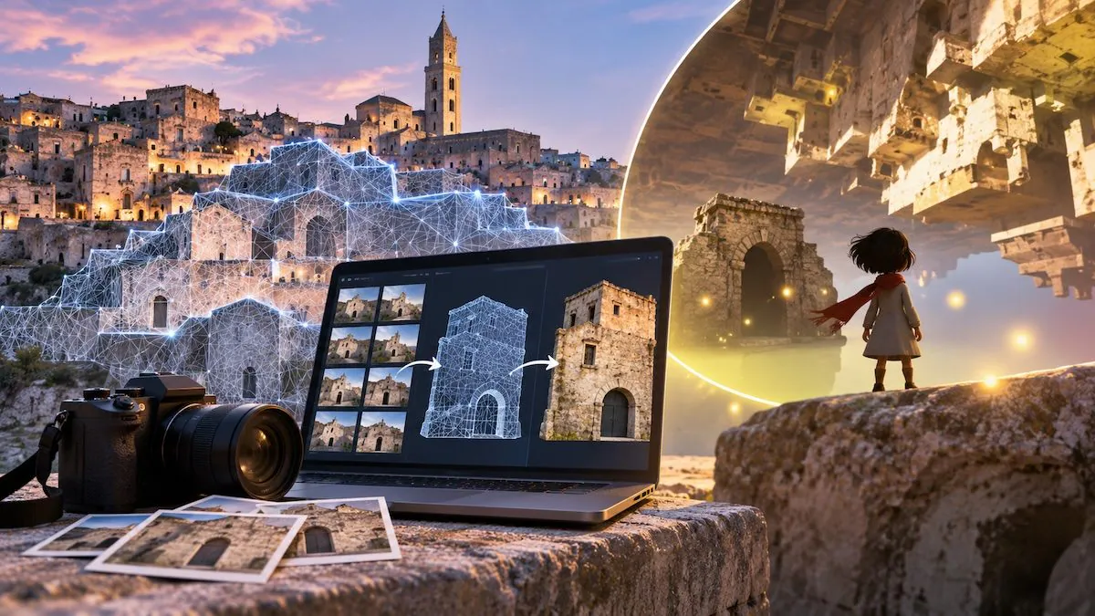
Photographs allow you to observe a place, but with the right technology they can even transform it into an environment to explore. This is what happened to the Sassi of Matera, which became the setting for Where The Light Sleepsan Italian video game available in Italian and English for free on Steam, the online platform that allows you to purchase and download PC games. To recreate some views of the city, the developers, who created it in just 48 hours during the “Matera hack for play” marathon, used photogrammetry, a technique that allows you to obtain three-dimensional models starting from a series of shots.
Its use, however, goes far beyond video games: it also finds application in archeology and the protection of cultural heritage, where it allows you to study finds, document historic buildings and monitor the state of conservation of monuments.
The video game set among the Sassi of Matera
Where The Light Sleeps was born during Matera Hack for Play, a 48-hour creative marathon organized in November 2025. Six people developed it and the project took second place in the Lucana Film Commission special prize.
The adventure lasts about 7 minutes and follows a little girl in a world suspended between dreams and reality. Guided by her grandmother’s voice, the protagonist travels through places inspired by Matera, meets mysterious characters and collects small lights with a whistle. The story deals with themes such as memory, the connection with one’s origins and the loss of loved ones.
The settings take up some glimpses of the Sassi of Matera, characterized by houses, churches and other structures dug into the rock or built taking advantage of the conformation of the territory. Together with the Park of the Rock Churches, the Sassi constitute a single site recognized as a World Heritage Site by UNESCO in 1993, evidence of a settlement that developed over the centuries in close relationship with the natural landscape.
Where The Light Sleeps photogrammetry: how to recreate a 3D environment
The stone walls and openings of the Sassi di Matera buildings offer a concrete example to understand how to move from photographs to a 3D model. To digitally recreate a facade, instead of drawing every detail by hand, numerous images are taken from different angles. Photogrammetry then allows the software to compare them and reconstruct the geometry of the surface.
In order for the program to recognize the same details in different photographs, the shots must partially overlap. In many surveys, indicative overlaps of 60-80% between consecutive images are used, although the values may vary depending on the subject and technique.
One of the most popular methods is Structure from Motion (SfM), literally «structure from movement». The software identifies elements common to photographs, such as the edge of a window or a particular stone, and analyzes how their apparent position changes in different shots. From these comparisons it estimates the positions from which the images were taken. The principle is reminiscent, in part, of the way our eyes perceive depth when observing the same scene from two slightly different perspectives.
Through geometric calculations based on triangulation, the program estimates the position of numerous points on the photographed surface, creating a first point cloud. This representation can subsequently be made denser and used to generate a 3D mesh, i.e. a surface composed of small polygons connected to each other. Textures can be applied to this, images that convey the colors and details of the materials: a digital wall can thus reproduce the appearance of the original stones.
The process is different from that of LiDAR, which measures distances using laser pulses. Photogrammetry instead reconstructs geometry starting from photographs. The two techniques can be used together to obtain more complete surveys.
The resulting model can then be adapted to a video game. Developers can reduce its complexity to make the computer’s workload easier, then add lighting, visual effects and interactive elements. However, the quality of the reconstruction depends on the number and resolution of the photos, the light conditions and the angles. Uniform, transparent or reflective surfaces can create difficulties; furthermore, the parts not photographed cannot be faithfully reproduced with this method.
From archeology to the conservation of cultural heritage: other uses
The transition from photographs to a 3D model is also useful for studying finds and monuments. In archaeology, these reconstructions allow us to examine the shape of objects without continuously manipulating them and to document very large structures. Models can also be shared between scientists working in different locations, facilitating comparisons between observations and measurements. Drones can also be used to photograph roofs and difficult-to-reach areas.
An example of the combined use of different technologies comes from the archaeological investigations in Gran Pajatén, Peru, where photogrammetry was used together with LiDAR to study the structures of the ancient Chachapoya civilization.
In Italy, photogrammetry was also used in the Villa of Diomede, in the Archaeological Park of Pompeii. A high-precision three-dimensional model was created with images taken from the ground and from a drone. The survey covered over 3,800 square meters and was integrated with historical documentation and archaeological data to study the different construction phases of the villa. Again in Pompeii, this technique was also used to analyze some traces of impact on the walls of the ancient city, as part of research on the hypothetical use of a repeated-fire weapon.
One distinction is fundamental: photogrammetry documents a building as it appears at the time of the survey, but cannot establish on its own what it looked like in the past. To reconstruct its appearance before collapses and transformations, further scientific sources and interpretations are needed. A disappeared wall, for example, cannot be reproduced with certainty by merely observing what remains of it.
These models then help to monitor the state of conservation of an asset. By comparing measurements taken at different times, experts can identify deformations or losses of material, provided that the measurements are accurate and comparable. Unlike a setting created for a video game, in fact, it is not enough to obtain a visually realistic result, but reliable dimensions and, when necessary, metric references and coordinates are needed. During scientific surveys, control points or reference scales can therefore be used to link the model to real measurements.
The model also constitutes a digital documentation of the state of a work at a given moment. If the asset subsequently suffers damage or transformations, the model can offer valuable information on previous conditions and help plan interventions. However, it does not replace the original nor does it allow you to automatically recover what has been lost.
Finally, the models can make finds and places that cannot be visited for safety or conservation reasons accessible through virtual tours and museum applications, also allowing you to closely observe details that are difficult to appreciate during a traditional visit.