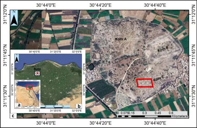
A recent study has identified a mud brick structure dating back to at least the 6th century BC at several meters of depth using satellite radar and electrical resistivity tomography, demonstrating that these two techniques can guide excavations in even very complex contexts with unprecedented precision. The study, published on Acta Geophysicafocused on the least investigated area of the Tell el-Fara’in site, ancient Buto, in the northwestern Nile Delta. It is one of the most stratified sites of ancient Egypt: its history goes from the Predynastic period (4000-3000 BC) to the Islamic era (7th century AD), passing through the Old and New Kingdoms, the Late period, the Ptolemaic and Roman eras. Centuries of association have made it a tell (hillock born from the stratification of several archaeological phases) formed by overlapping layers of mud bricks.
The Nile Delta poses specific challenges: the water table is shallow, the deep levels are unstable, and the layer density makes traditional extension excavation inefficient without prior guidance. The first phase of work used SAR images from the Sentinel-1 satellite, processed with the software open source SNAP. The radar penetrates the ground and detects structural changes indicative of buried buildings. The processing identified a large anomaly with an oval outline, which guided the next phase.
Electrical resistivity tomography (ERT) measures the resistance of the soil to the passage of current: bricks, sand, stone and voids produce characteristic profiles, depending on how they react. The results show a stratigraphy on three levels. Between 0 and 3 meters there were widespread anomalies consistent with disturbed material from the Ptolemaic or Roman era (4th century BC – 5th century AD). Between 3 and 6 metres, a high resistivity anomaly was interpreted as a mud brick structure from the Saitic period, of the XXVI Dynasty in the Late phase of Pharaonic Egypt, between the 7th and 6th centuries BC. Between 6 and 7 metres, there was then a layer of sand identified as an artificial leveling surface from the same period, probably for construction purposes.
The extensive excavation, over an area of 10×10 metres, confirmed the interpretations. Mud brick walls and artefacts related to the cult have emerged: faience amulets of Isis, Horus, Taweret, Bes and Wadjet, the patron goddess of Buto; a limestone Wadjet amulet; a bronze statuette of Horus as a child; a steatite scarab with the name of Thutmose III (pharaoh in the mid-15th century BC) and fragments of statues. The complex therefore indicates a funerary or cultic function during the XXVI Dynasty, when Buto was an important religious center in Lower Egypt.