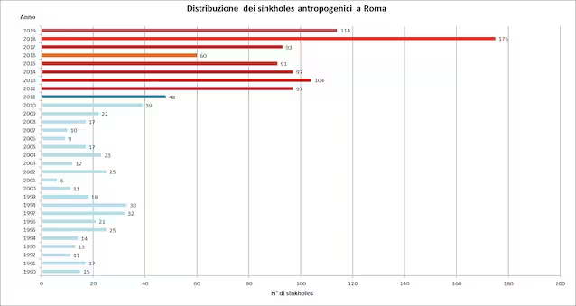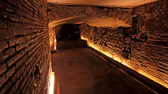
In Rome there is a city under the city, made up of a vast network of underground cavities dug by man, covering over 32 km2 of territory. They have now been surveyed and mapped in the Map of the underground cavities of Rome, edited by the Department for the Geological Service of Italy of ISPRA (Higher Institute for Environmental Protection and Research). The cavities are quarries, catacombs, aqueducts and military shelters dug over millennia. Knowing that tunnels and tunnels are hidden under the city is fascinating, but these voids represent a risk for the population and for buildings and infrastructures. In certain conditions, they can favor the collapse of the ground above, giving rise to chasms called anthropogenic sinkholes. In Rome over 100 sinkholes open every year. Even if their knowledge is still partial, the paper represents a notable step forward, achieved within the project “Census of underground cavities in Rome”. The result is the work of a working group involving various bodies including the CNR and the National Civil Protection.
What do they consist of and how were the cavities mapped?
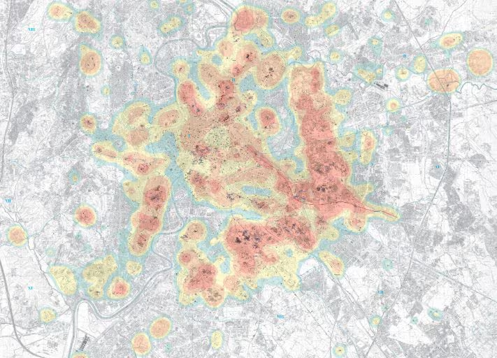
The cavities are mainly concentrated underground in the historic center and in the eastern part of the city. They are all of anthropic origin, created by man for the most diverse purposes: mining, religious, hydraulic and military.
- Mining use. The most widespread cavities, especially in the eastern part of the city, are quarries for the extraction of building material, in particular volcanic rocks such as tuff. In the southwestern part, smaller quantities of gravel, sand and clay were extracted.
- Religious use. They are the most widespread cavities after quarries. These are catacombs with a funerary function, especially Christian and to a lesser extent Jewish, and sanctuaries, with a ceremonial function of worship.
- Hydraulic use. These cavities had the function of aqueducts and tunnels for the regulation of rainwater and for the drainage of waste water.
- Military use. These are shelters and bunkers that could provide shelter for the population in times of war.
Over the last thirty years, with the urban development of Rome, numerous studies have been conducted on the city’s underground cavities. These have produced a fragmented amount of data, which have been added to the historical data. The data coming from cartographic archives, archaeological maps, technical reports present in the municipal archives and direct investigations carried out underground have now been collected and organized with a census. It was thus possible to use them to create the Map of Rome’s underground cavities, which offers an unprecedented vision of the city’s subsoil.
Sinkhole risk: the importance of the study
Knowing with the greatest possible precision where the voids in Rome’s subsoil are located and what size they are is essential. Their presence in fact constitutes a potential risk for citizens, buildings and infrastructures, because their vault can collapse, with the subsidence of the ground above. Thus, chasms called sinkholes are formed sinkhole anthropogenic, similar to karst sinkholes.
The phenomenon is generally triggered by leaks in the water network or intense rains that weigh down the ground and remove rocky material from the vault of the cavities, weakening it. In recent years, an increase in anthropogenic sinkholes has been recorded in Rome. This is partly due to increasingly intense urbanisation, with the construction of buildings even directly over voids, and partly to the greater frequency of extreme weather events due to climate change. Knowing the distribution of sinkholes allows you to prevent the resulting risks with correct urban planning and the preparation of reclamation and safety interventions. With this in mind, the map will be refined and updated as new data is acquired.