The earthquake Of Sichuan, which occurred in southwestern China on May 12, 2008 at 2.28 pm, it was one of the most violent earthquakes ever recorded in the area, whose magnitude reached a magnitude of 7.9. The impact of the quake – with its epicenter in Wenchuan county – the central region of Sichuan province, was catastrophic. Villages and cities were razed to the ground, almost 70 thousand people died, including over 5300 students, while more than 5 million people were forced to abandon their homes. 18 years after the event, the reconstruction appears to have been completed, with total investments exceeding 150 billion dollars.
May 12, 2008: reconstruction of the event
The first shock, the most violent, was recorded by Chinese seismographs at 14:28:01 (local time) on 12 May 2008. The hypocenter of the earthquake was located at a depth of approximately 19 km, with the epicenter near the city of Dujiangyan, approximately 90 km north-west of Chengdu, the capital of Sichuan province. Most seismographs recorded a magnitude of 7.9 degrees.
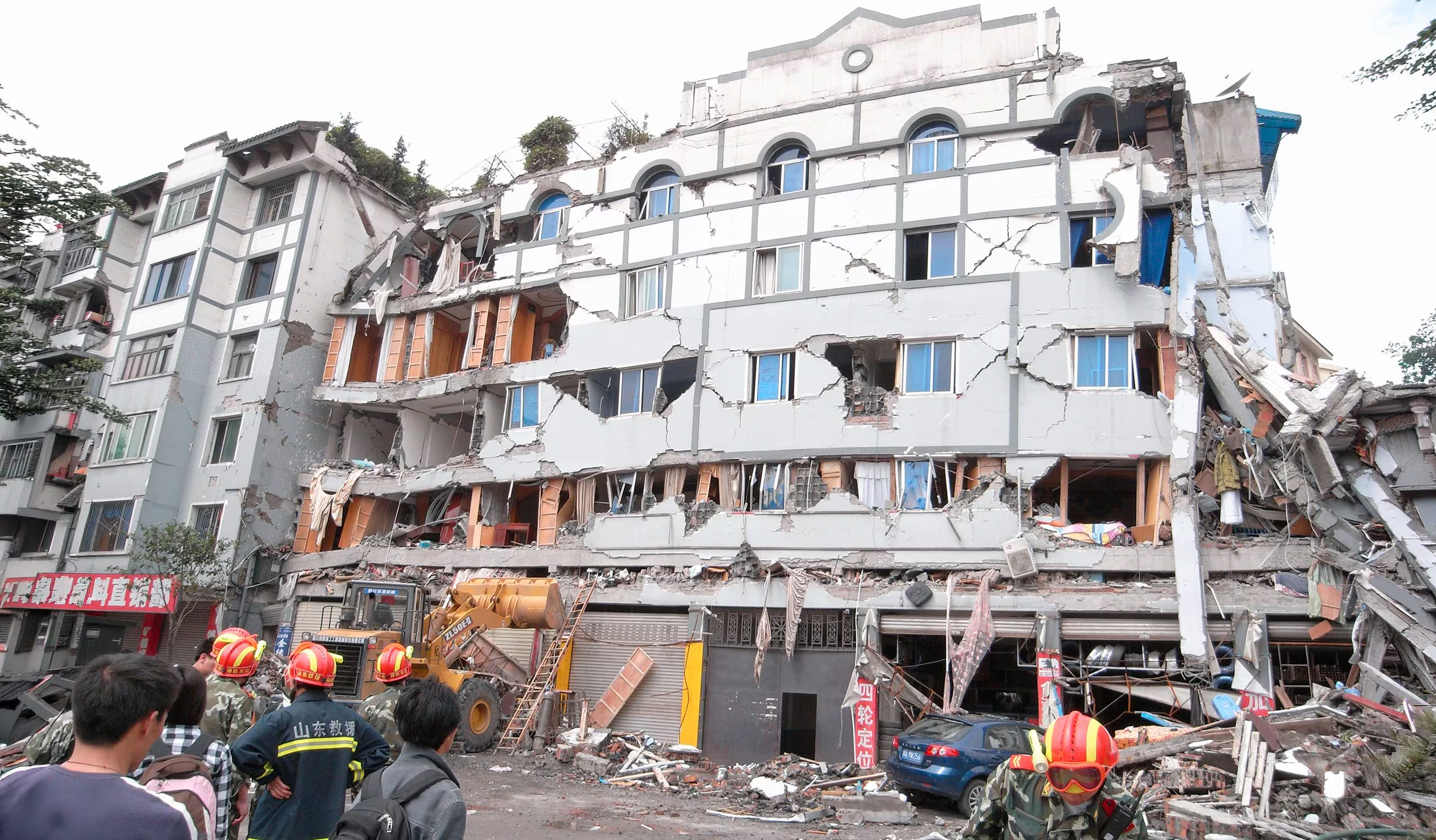
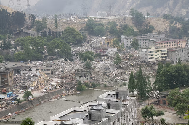
The effects of the earthquake were immediately devastating and spread over an area of approximately 110,000 km². According to the official report published one year after the disaster, over 45.5 million people, distributed across ten provinces, were affected, to varying degrees, by the earthquake. The final toll reached 69,185 victims, to which were added 374,171 wounded and 18,467 missing. Among the victims were over 5,300 students, most of whom died due to the collapse of school buildings during lessons. Additionally, more than 15 million people were evacuated. An estimated 5.36 million buildings collapsed, while another 21 million suffered serious damage, leaving over 5 million people homeless.
The earthquake was associated with various coseismic phenomena, activated in the minutes and hours following the main shock. Among them, a landslide in Qingchuan County buried about 700 people. Numerous other landslides blocked the natural course of several rivers, forming dam lakes and dangerous accumulations of water that threatened the villages and populations located downstream. Over 2400 dams, more than 53,000 km of roads and around 47,000 km of water pipes were damaged. About 1.5 km of surface faulting was observed near Qingchuan; furthermore, in the months following the earthquake, other fractures and surface cracks were identified on three mountains in the area. The overall estimated economic loss reached US$86 billion.
Multiple aftershocks followed in the days, months and even years following the 2008 earthquake, including a magnitude 5.0 earthquake that hit the Chengdu area in May 2010 and another magnitude 6.6 earthquake in April 2013. The latter event killed around 200 people and left more than 13,000 injured.
The geological causes: the Longmen Shan fault
Sichuan is located in one of the most geodynamically active regions on the planet, located in the context of the collision between the Eurasian and Indian plates. The latter moves roughly northward at a speed of about 4 cm per year, penetrating the Asian continent and pushing the Tibetan Plateau eastward. This is the same continental collision, which began around 50 – 60 million years ago, which led to the formation of the mountain range with the highest peaks in the world, the Himalayas. This observation is already sufficient to understand the extent of the natural-tectonic forces at play in the area. In fact, high magnitude earthquakes associated with this continental collision are relatively frequent. Among the most recent events are the 5.9 magnitude earthquake that hit Pakistan on 6 October 2021 and the 7.1 magnitude earthquake that affected Tibet on 7 January 2025.
Seismological analyzes located the epicenter of the Sichuan earthquake along the Longmen Shan fault, a reverse fault, or thrustwhich separates the Longmen Shan mountain range of the same name, located on the eastern edge of the Tibetan Plateau, from the Sichuan basin to the south-east. In particular, the rupture would have started near the city of Chengdu, then propagated towards the north-east for over 200 km in the space of about 50 seconds. In some places, the movement of the fault caused a relative displacement of the rocks above and below the fault plane equal to 12 meters.
The geodynamic context in which Sichuan is located makes the region highly subject to seismic risk. In fact, already in 1933, an earthquake of magnitude 7.5 was recorded. According to experts, seismic events of similar intensity could occur again in the future.
The phase following the earthquake
In the hours following the earthquake, the Chinese government deployed 130,000 soldiers and numerous rescue teams, to which were added 100,000 professional doctors from different parts of China and economic and humanitarian aid from non-profit associations and numerous nations, including Italy and Germany. In the following months, however, an intense reconstruction phase began, supported by investments that exceeded 150 billion dollars. Over 41,000 rebuilding and rehabilitation projects were developed, most of which focused on key sectors, such as education, health, infrastructure, environment and social care. The numbers are impressive: over 3.5 million homes in rural areas and more than 1 million in urban areas were rebuilt, to which must be added 18 million m² of schools, 7 million m² of hospitals and healthcare facilities, and approximately 27,000 km of national, provincial and rural roads. Already between 2011 – 2012, the Chinese government declared that well over 90% of these projects had been completed. Today the reconstruction plan seems to be concluded. However, there still remain destroyed towns or villages left in the hands of nature, as well as areas where the population has been completely relocated.
Although it was not the first earthquake experienced by the local population, the 2008 earthquake was certainly the most devastating, with profound consequences also on a social and political level. Numerous studies and controversies focused on the lack of adequate anti-seismic measures in buildings and, in particular, on the poor quality of school buildings, built quickly and at low cost during China’s strong economic boom. According to several experts, the adoption of more rigorous anti-seismic standards could have saved several lives.
In the years following the earthquake, the Chinese government invested significantly in the development of seismic early warning systems, with the aim of reducing casualties and damage during future natural disasters. Furthermore, since 2009, May 12 has been officially designated as “National Day for Disaster Prevention and Reduction”. In this context, educational activities were also promoted, including anti-seismic exercises in primary and secondary schools and information lessons dedicated to understanding the main natural risks.