Google has announced a series of major updates to Google Maps and Google Earth, all powered by Gemini artificial intelligence. Presented during Google Cloud Next (a conference scheduled for these days organized by the Mountain View giant), the innovations revolve around three key ideas: creating realistic images starting from real data (Maps Imagery Grounding) designed for construction and cinematographic uses, automating the analysis of satellite images and making ready-made AI models available to interpret the territory. The goal is to save time for those who work with geographic data (companies, urban planners, analysts, etc.) by making everything faster and scalable.
Maps Imagery Grounding with Gemini coming to Google Maps
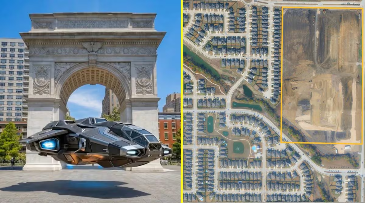
Among the most interesting innovations is the Maps Imagery Grounding technology, which allows you to generate visual content anchored to the real world. In practice, AI does not invent landscapes from scratch: it builds them starting from Street View images, with coherent and credible results. Through the Gemini Enterprise platform, you just need to describe a place in words to get an image that looks like it was taken there in a few seconds.
The practical implications are immediate. In cinema, for example, locations can be simulated without physically moving, reducing costs and times to carry out inspections. In marketing, agencies can set their campaigns in realistic urban contexts without organizing shootings around the world. And by integrating tools like Veo (a Google model that allows you to generate videos with AI) you can go directly from an idea to an animated sequence.
Geospatial analysis becomes automatic
Google is also working to make analyzing aerial and satellite images much easier. Until now, examining this type of data meant relying on human operators manually scrolling through huge amounts of visual material: a slow process full of margins of error.
With the new integration into BigQuery, Google’s cloud platform for data analysis, all this can be automated. The result? Operations that previously required weeks of work can now be completed by city planners and data analysts in minutes. A huge advantage for figures like these who deal with urban planning and who, thanks to this technology, will be able to monitor the expansion of a city, identify active construction sites or plan new infrastructures in a much simpler way than before.
The new Earth AI Imagery models
To complete the picture, two new Earth AI Imagery models arrive, available in the Google Cloud Model Garden. These models are designed to automatically recognize infrastructure elements in images – bridges, roads, power lines, etc. – without companies having to build and train similar systems from scratch, which requires specialized skills and months of work.
The usefulness of these tools clearly emerges in emergency situations, such as those due to natural disasters of various kinds. After a flood or a violent storm, quickly knowing where the greatest damage is concentrated can make the difference, both in the first rescue operations and in being able to make an initial estimate of the damage.
Companies like Vantor, specializing in spatial intelligence, already use these models to transform raw satellite images into operational information: blocked roads, debris, areas to be reached with priority. An analysis that would previously have taken days is now done automatically, with direct benefits for communities affected by disasters.