Drawing a map does not exclusively mean describing the world: it means choosing what to show, what to simplify and what to hide. For this reason, for centuries, maps have not only been tools for orientation, but also weapons, deception and instruments of power. Sometimes the cartographers made mistakes by mistake, but very often they lied on purpose. Imagine following the navigator towards a destination that simply doesn’t exist. It really happened to those who were looking for Argleton, an English town that appeared for years on Google Maps complete with weather, job adverts and properties for sale. Too bad Argleton never existed. An extreme but perfect case to talk about an ancient practice: inserting false information into maps. Invented roads, ghost islands, territories moved not out of distraction, but to protect secrets, defend rights or control the narrative of the world.
Trap streets: streets that lead nowhere
Creating an accurate map requires years of work, economic resources and technical skills. So there is a need to protect your investment: how to prove that someone copied you? The solution found by the cartographers is as simple as it is counterintuitive: insert a voluntary error. A false, tiny, but recognizable detail. This is how trap streets were born, literally “trap streets”. They could be streets that don’t exist, slightly wrong curves, bridges with slightly altered measurements. If the same error appears in another map, the copy is obvious.
In the 1990s, the Thomas Brothers Map Company admitted that its Los Angeles guidebooks contained between 100 and 200 invented streets, mostly in San Bernardino and Riverside counties.
With digital cartography the mechanism has not changed. Databases such as Tele Atlas, also used by Google Maps, have included streets visible only on the screen, such as Oxygen Street in Scotland or a London Moat Lane which, in reality, was just a group of houses and trees.
Ghost islands: when the mistake becomes legend
If a non-existent street can make you choose the wrong neighborhood, a non-existent island can make you choose the wrong ocean.
The phantom islands are lands that have appeared on maps for centuries, considered real by navigators and governments, only to later discover that there was nothing to find. Some arise from technical errors: wrong coordinates, imprecise instruments, difficult navigation conditions. Others, however, are the product of stories, optical illusions and geographical legends that no one was in a hurry to deny. A new island could mean prestige, colonial ambitions, new trade routes:
- Hy-Brasil, west of Ireland, promised riches and mysterious knowledge.
- Gamaland, east of Japan, attracted sailors with a reputation for fertile lands.
- Sannikov Land, in the Arctic Ocean, cost the lives of part of a Russian expedition led by Baron Eduard Toll, in 1902 the explorer set off on foot towards the island and never returned.
Behind many of these visions there was the fata morgana, an optical phenomenon which, due to the refraction of light in layers of air at different temperatures, transforms ice and distant coasts into very solid mirages. Not surprisingly, in 1875, the British Royal Navy deleted 123 non-existent islands from its charts of the North Pacific in a single update.
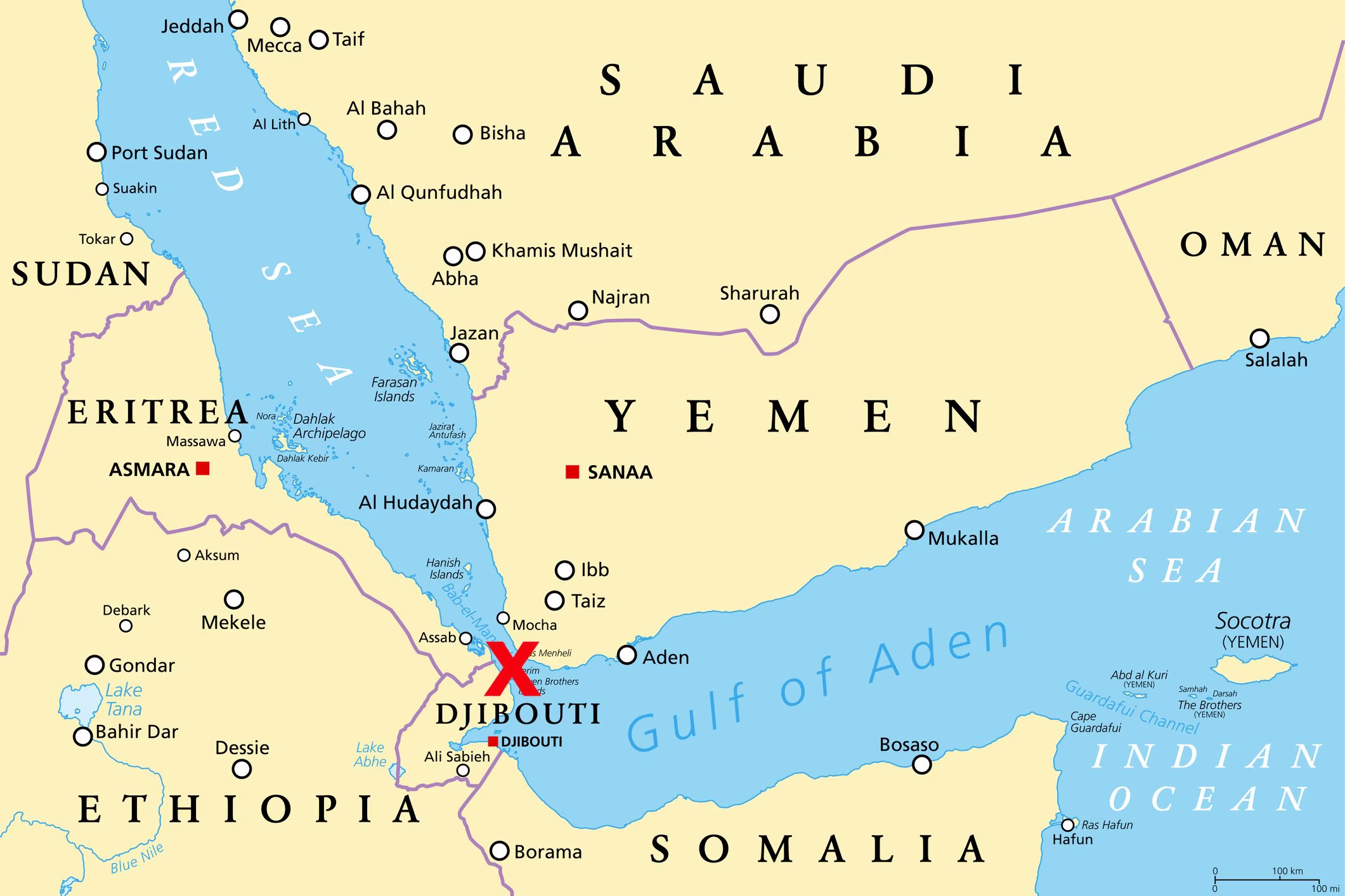
Bermeja, Frisland and the ghosts that moved the borders

Some ghost islands have not remained simple cartographic curiosities. They had political and diplomatic consequences.
- Bermeja appears in a 1539 map dedicated to Yucatán. In 1540 a Spanish cartographer indicated its position with great precision: latitude, distances from the coast, geographical references. For centuries no one doubted its existence. The problem is that no one has ever found it. Expeditions of the eighteenth century, research of the twentieth century and missions of the Mexican government between 1997 and 2009 – also linked to the possibility of extending the exclusive economic zone and the rights to possible oil fields – all returned empty-handed. Today Bermeja is considered a classic ghost island, surviving on maps by inertia.
- Frisland is the opposite case: a land designed with such great detail that it seems real. To the south of Iceland, more or less the size of Ireland, rich in ports and toponyms, it appears between the 16th and 17th centuries on the maps of Mercator and Orthelius. According to tradition it was discovered by the Zeno brothers; explorer Martin Frobisher even went so far as to claim it for the British crown. Only with more systematic explorations did Frisland slowly disappear from the maps.
In these cases, the line between error, myth and political convenience is thin. An ink stain could be enough to justify expeditions, fuel ambitions, move boundaries.
Secret maps of the Soviet Union
In the twentieth century the cartographic lie changes scale. During the Cold War, the Soviet Union (USSR) built one of the largest and most secret mapping programs ever: thousands of military topographers produced highly detailed maps of cities and regions around the world, often more accurate than local ones. For example, the maps of Afghanistan indicated when the mountain passes were free of snow, those of China reported information on vegetation and water quality. Even more impressive were the maps of Western cities: Washington, San Diego, European industrial centers, described in detail with building materials, bridge spans, electrical networks, railways and even street trees. The paradox was evident: while the army had extremely precise maps, Soviet citizens only had access to inaccurate and deliberately misleading maps. Roads moved, neighborhoods simplified, sensitive infrastructure omitted. In this case the maps were lying, yes, but to hide other, much more detailed and secret maps. After the collapse of the USSR, those cards became valuable to companies, governments and humanitarian organizations.
What lying maps teach us today
In the past it was enough to move a coast to claim a territory. Today an invented detail can unmask plagiarism. The tools change, not the logic: we continue to trust representations produced by states, companies and platforms with specific interests. The satellites have canceled many ghost islands, but not the risk of new mirages. Incomplete data, algorithm errors, poorly interpreted images can create other wrong maps. Until someone goes to check on the field, there will always be a small margin where – once again – the map could lie.